
McCoy Creeks is a bitty trib of the Cispus near Randle Washing. Bennet calls for 150-600 cfs at 5-15% of the Cispus at Randle. We had about 3K there giving us a calculated 150-450cfs but I swear it was more than that. Its been a banner snow pack year in the Northwest so getting with almost all the water coming from up top our own visual estimates were more along the 600cfs range. You can look at the photos and make up your own mind though.
McCoy is a fairly rarely run and often over looked high quality creek that is probably over shadowed by close by runs, the Upper Upper Cispus , the Ohanepecosh and the Clear Fork of the Cowlitz. While it may not have the draw of the other better known runs, its packed with fun ledges and some big slides and combo drops. There’s even a good sized waterfall just to round out the experience.
Casey, Rick, Jame, Richard and I met the bridge over the Cispus on FR 23 at 9:45AM. Rick and I met up in the morning, the other three had camped up there the night before for a shake down cruise in his new EuroVan.
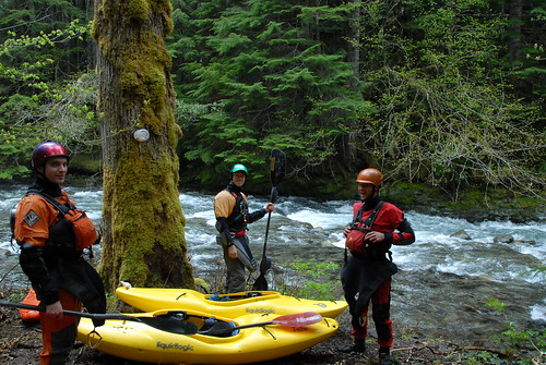
Put on grins
Rick and I had done this one once, about a year before the other three were new to the run. McCoy Cr on Oregon Kayaking.
It looked a bit higher than last time and there were few eddies in sight. There was a nervous pause at the put in and a brief hesitant conversation then ended with us putting on happily but nervously but that could have had something to do with the miners with guns and a stuck pickup truck down the put in path.
As it turned out Rick and I had forgotten most of the run which is a real shame considering the number of quality drops that are in there. I was constantly anticipating the pothole drop around every bend fearing wood in the narrow channel allowing you to skirt the pothole.
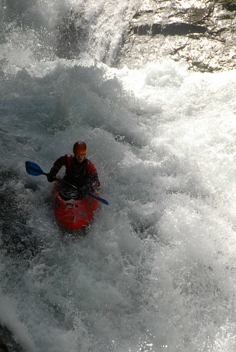
Richard finishing up the drop with the pothole. We all ran left.
Rain forced me to put the camera away after a few misty photos of the first big slide. We all ran down the right skirting the pocket hole on the left. The next major drop is a tight double drop with a log filled bouldery s-turn lead in. The line is clear but the potential for carnage is obvious.
Richard below the tight double drop.
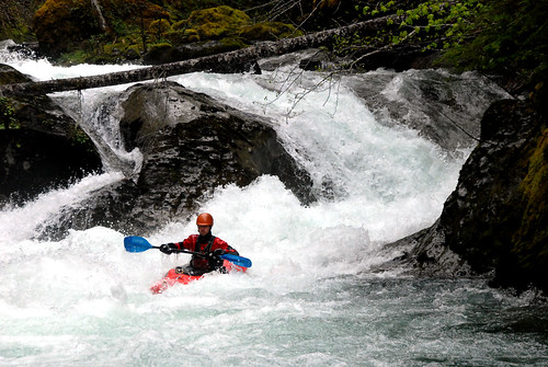
The next big drop is Chinook Falls, or as the Bennet Guide calls it. BUD (Backwards and Upside Down). The lead in to Chinook lurks around a tight right hand turn that currently has wood most of the way across guarding the normal scout eddy. It’s a little bit of a scramble to make it, but there are other eddies available before being committed to this 50ft + three tiered slide.
Chinook starts with a twisty, boily lead in to a 6-8 ledge that you want to boof with left angle. The right side is ugly and will probably result in a quick and unexpected trip down the center of the last slide, into a nasty hole.. that is, if you make it through the crack there. Out of the 5 of us, we had on walker. The 4 that ran it, nobody had exactly a clean line of this ledge. The eddy between the last two drops is swift.
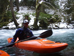
 Me on the entrance to Chinook from an earlier trip. Photo by Rick Cooley
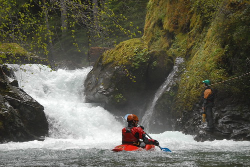
James halfway through Chinook Falls workin to stay in the eddy
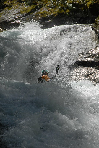
The last part of the drop is a wide slide, clean down the right and nasty down the middle to left. There’s some video floating around of a Portland boater getting sucked back into that hole. It seemed to flush more at our flows though, and a good thing too as James, who didn’t quite make the line, gutted the bottom hole but came out upright and just fine.
Richard finishing up the bottom slide of Chinook Falls
After bombing down through some fun and clean ledges you eventually make it to the big runnable falls. The book calls it 20ft. They also suggest a portage.
Silly books. The falls is super fun and we had runs down the right for a plug and doen the middle for a boof. I recommend strong left to center momentum as the left wall hooks in and the current will push you into it. I ended up again the wall rolling and getting pulled back in. Not fun when a 40' un-runnable drop is just downstream.
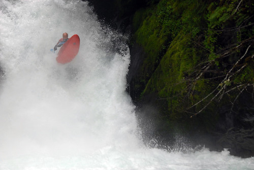
 The right line at the 20ft falls. Photo by Rick Cooley.
Richard really hit the boof on the '20ft' falls.
The big portage was next up and though I've heard of a better way, we instead went up and around and roped the boats down a couple hundred feet before 'schwacking down to river level. Once down there and after a short breather, Rick paddled across and looked upstream at the clear path down to the river.
Shortly after that, the confluence of Yellowjacket and a mile or so of read and run class IV followed by a couple more miles of annoying class II.
Unfortunately, my shoulder was too sore in the morning to paddle on Sunday but we spent the better part of it driving around anyway. We found out that the road to the Super Slides run on the Cispus still has plenty of snow miles from the take out and that the put in for Smith Creek is REALLY steep.
Check out more photos here.
Till next time!


No comments:
Post a Comment